Topographical maps:
The purpose of topographical maps is to allow you to see the lay of the land, so to speak, from a distance. Is the parcel on a mountain side too steep to build on, or in a swamp, or in a situation where seasonal flooding is likely? The contours of a topographical map will show you. If you are not quite sure how to read a topographical map, in addition to the helps available at www.trails.com, we find that the best and most understandable introduction is the Boy Scout Orienteering merit badge book, available at any Boy Scout office. We figure that since it is written for 12-year-old boys, it should be pretty understandable for us, too.
We will look at several of them here:
Digital Topo Maps: www.digital.topo.maps.com is the easiest to use of all these sites, and is free of charge. It works on a Google Maps platform, but along with the "Map" and "Satellite" views, you can select "Topo." Now you see the area with a full-fledged topographical map with which you can move around and zoom in or out just as with the Google satellite image. The elevation lines are marked and you can see exactly what the lay of the land looks like.
Bear in mind, this particular service is free-of-charge, but the company behind this services has lots of products you can purchase. They are probably high quality and useful, but our thouight is for you to use the free service, not for you to buy stuff: however, you decide for yourself.
TerraServer: www.terraserver.com provides decent quality satellite imagery, but has features that the other satellite image sites lack:
 1. You can search with either coordinates or PLSS numbers, as well as by address (select the appropriate
tab in the search box).
2. Below the search box you will see image information showing the image date. This way you know how
recent the picture is.
3. Latitude-longitude information is available, as well.
The search function is in the middle of the tool bar at the top of the page, allowing search by place name or township. When you select township, your first box to fill in is the name of the state, and the site will fill in the Meridian for you (or give you appropriate choices, if the state has more than one). This is very handy if you don’t know the name of the Meridian by heart (and those in the Midwestern states are numbered, making them less than easy to remember). When you click on the search button, the search results appear in a tan bar below. When you click on the magnifying lens icon labeled “Zoom,” the map will then show the selected township. You should read the information found under the “Quick Start” tab for an overview of how to use this.
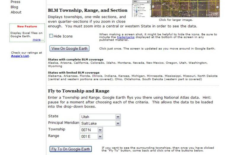
Earth Point: www.earthpoint.us is is a service of the Boise, Idaho, Board of Realtors, and supplies the most powerful source of PLSS information, because it not only displays the Townships but also the Sections, and overlays these on Google Earth. To use this tool, first select “Township and Range” under Utilities on the left column of the home page. The resulting page view looks like this:
Then you download the program by clicking on the button labeled “View On Google Earth.” Once you have installed the program you can input the state information below (“Fly to Township and Range”). If you add the state name, the program will provide you the Meridian choices.
You will want to note that this program has geographic limits, as outlined in the paragraphs below the “View On Google Earth” button.
Environmental maps:
People might want to know whether the property they may buy from you involves environmental hazards. You can check this in advance at www.epa.gov/envirofw. This service of the Environmental Protection Agency of the Federal government allows you to look up a map by zip code which will show you EPA regulated sites. When you open the site and input the zip code, a map appears. At this point you want to make the map interactive. Simply click the link immediately below the map: “To view the above map interactively, click EnviroMapper” When interactive, you can move the map’s center point around, zoom in, and obtain specific information about various regulated sites that are depicted on the map. Note that the legend to the right of the map identifies the significance of the colored squares that mark regulated sites. Note, too, that by clicking on these colored squares, you get a report of the facility (it might be a school, a tire retailer, a print shop, or an animal rendering plant – in other words, some are innocuous, others you might wish to avoid). Also, the page shows a summary of the area at the bottom.
GIS mapping services:
GIS comes from “Geographic Information System.” We define this as a collection of computer hardware, software, and geographic data for capturing, managing, analyzing, and displaying all forms of geographically referenced information.
Quite often a county will manage a GIS mapping service; when so, you can find that under the county listings on www.netRonline.com. Not all counties provide an online GIS mapping service, however, in which case you will have to be content with parcel maps. As an example you can find a very powerful GIS service at GeoData.org. (Hint: to look up a parcel with this map, go to an online telephone directory and look up a reasonably common family name in Olympia, Washington: obtain the home address, and plug that into the Parcel Search feature of this site.) The first result page of a parcel search on this site provides you four different map views, three of which we discuss later in this article. The first one, however, "Zoom Map to Parcel" opens the county GIS map. Pay attention to the tool buttons below the map and the Layers and the Legend to the left of the map.:
Street maps with satellite photographic images:
There are numerous online mapping sites that include satellite photographic views. Some of the prominent such sites are:
Each of these sites is very similar, but you will find that one or the other might give you better photographic resolution than the others in different parts of the country. In some cases, you see the image as though you are flying at 20,000 feet, and cannot zoom in closer, whereas a different mapping site might bring you in close enough to identify specific vehicles on the streets. Also, the satellite images among these sites were created on differing dates – in other words you might find a more recent photograph with one over the others. Each site has button commands to allow you to toggle between street map, photographic image or a combination of the two.
Two of these sites offer additional features that help us in looking at a property from a distance. Bing Maps offers a feature called “Birds Eye View” that in certain locations lets you see the land as though you are flying around the area – but not from directly overhead, rather at a 45° angle. You can see Manhattan, Austin or Sacramento from a couple of hundred feet overhead. You can also see the same object from the four directions, from the north, the south, the east or the west, to get a all-round look at a property, but rather than directly overhead, at an angle that lets you see the facing wall of a building, or under a canopy of trees to see the land.
Furthermore, Google Maps has a “Street View,” which allows you to see what a person standing on the street will see. As long as the street is marked with the parallel blue lines that indicate street view, you can place a human figure on the street and see exactly what you would see if you were standing there – and also pan around 360° and look upwards or down. This you do my continually zooming in closer until the street-level view loads onto your screen, or by grabbing the little gold man-icon from the top of zoom tool and placing in the middle of the street that you want to see.
Although MapQuest does not have features beyond the straight overhead satellite image, it does allow searches using latitude-longitude coordinates, very handy when an undeveloped parcel does not have a street address.
Demographic information:
As you qualify a county or local area to decide whether you want to work with properties in that area, it is handy to have access to demographic information – information about the characteristics of human populations, such as size, growth, density, distribution, and vital statistics, as well as things of interest to whoever might want to purchase a property, such as cultural amenities, employment opportunities, recreational features, etc.
There are several places you can go to get information about an area that goes beyond what it looks like. It is good to know what the population of an area is: even better, it is good to know what kind of population you have, what the economy of an area is like, and whether or not the area has such features as shopping, schools, fire protection and recreational facilities.
U.S. Census Bureau: www.factfinder/census.gov: This gives information on such demographics as total population, median age and portions of population over or under certain ages, median
household income, population below poverty level, and home ownership percentages. It also
compares it to the rest of the country. Now you can get a good feel for what that area is like
demographically and economically.
Google Earth: This is a program that you install on your computer. First go to the Web site at www.earth.google.com and then look for the large button inviting you to download the free version of Google Earth. Follow the instructions given, and it will install the program to your computer. You can also pick up some tips and information at the Web site on what you can do with Google Earth, as well as take a tutorial within the program.
Your greatest value in Google Earth is not so much in the satellite imagery, which is basically the same as with Google Maps, described above, but with the demographic and economic information available within the“Layers” depicted in the lower left-hand portion of the page within the sidebar. Within layers, you can select features by clicking on the small box to the left of each feature to place a check mark within the box. Some features break down into sub-features (e.g., “More” breaks down into such things as “Parks and Recreation Areas,” “Transportation,” “Wikipedia” and “Place Categories,” under which you will find Dining, Banks, Grocery Stores, Coffee Shops, Parks, Schools, Churches, etc.). By checking the box next to an individual feature, you can see icons placed on the map to show you locations of all the coffee shops, for example, in the local area. Placing the cursor over that icon on the map identifies the feature by name and address. When you advertise a parcel for sell, you can inform potential buyers about the area: is this parcel in the middle of civilization or is it out in the woods?
Be sure to activate the features “Panoramio” and “Wikipedia”on the layers list. Panoramio shows photographs of the area that somebody took and posted to www.panoramio.com. This is a photo sharing site for places, and many of the photographs you find will be very valuable for including in your online ad when you want to sell a nearby property. Simply click on the blue icon to view the image, then click again top make it saveable. Wikipedia icons are a “W” in a box and open enclypedia information about the town, city, county, feature or institution marked. This is a great way to get immediate knowledge about the area from the online encyclopedia.
You should also explore the tool bar above the map on Google Maps. These allow you to put a place marker on the map to make it easy to find a location later on – also to mark the property on a screen shot of the area for your advertisement. You can mark a path from point A to point B, and, in fact, measure the distance between the two points, either as a straight line (as the crow flies) or following the route of a curving road or turning from one street to another.
Note: Google Earth can find properties with latitude-longitude coordinates. You simply type them into the “Fly-To” bar where you would otherwise put the street address. Also, the latitude and longitude of the cursor on the map shows at the bottom-left corner of the map.
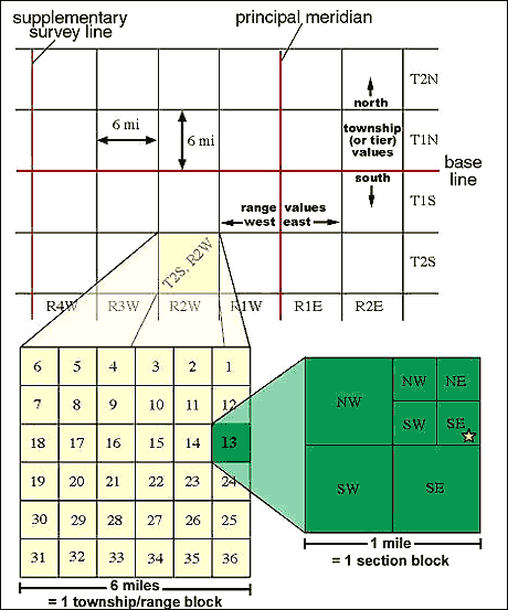
Public Land Survey System (PLSS):
This is a method of surveying land that was devised soon after the United States was founded and brought up to speed by the time the United States acquired the Louisiana Purchase in 1804. The PLSS plots a major portion of the United States on grids, mostly one separate grid for each state. The states that do not participate in this system include the thirteen original colonies and states that developed directly from them (Maine, Tennessee, Kentucky and West Virginia along with Texas) – the thirteen colonies maintained the older British system, and Texas utilizes a Spanish land grant system that it brought over from Mexico as it became an independent country before joining the union.
The PLSS grids center on a base line and meridian line that form an X and Y axes: the base line is horizontal and the meridian line is vertical. The lines on the grid as they move outwards from the center axis create squares as they intersect. The basic unit is called a township, and consists of 36 square miles (a square six miles to a side). The sub-division of a township is called a section, which is one square mile or 640 acres, a quarter section is 40 acres, and a quarter-quarter section would be 10 acres. See the illustration, below:
Getting a Look at Properties from a Distance
Mapping Sites to Help Inspect the Properties
When we are looking at unimproved properties, we have the luxury of not needing to check out the building, since there is none. We need not be concerned with termite infestation, fire damage or a crumbling foundation.
A huge benefit of not needing to look at improvements is that we can know what we need to know about a property without traveling long distances to see it. For unimproved land we can get most of the information we need online. We do this with a number of mapping and information sites.
Parcel maps:
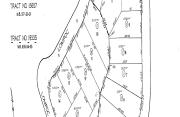
We obtain these at the county level. They are simple outline depictions of the property in relationship to the rest of the neighborhood. Often these are based on the plat maps that a developer must submit to the local governing agency for approval before development can begin. Often you can find these maps on the County Assessor’s Web site, in which case you can simply print them. If the county does not reproduce parcel maps on its Web site (or has no Web site), you then obtain maps by calling the County Assessor's Office. They may charge you anything from a quarter to a couple of dollars, but it is worth it. You don't know what you are buying unless you can see the parcel map. It will show you the size and dimensions of the lot and let you see how it relates to the other lots in the neighborhood. You can see where the property is on the street (or even whether it has street access) and such details as which side of the street is it on and how far is it from an intersection.
The map you see here depicts a page from the map book for the County of Los Angeles in California. The map books are very large, as many as 36 inches across. In California, the parcel number shows the book number and map number within the book along with the number for the particular parcel. The parcel shown here has the Assessor's Parcel Number (APN) 8673-037-004. This indicates that the map is found on page 37 of book number 8673 in the county recorder's records. Parcel numbers on these maps are circled, so you will find parcel 4 on New Hampshire Avenue where it begins to curve toward the west (note: the arrow indicates that north lies to the left on this map). Although it may be difficult to see here (remember, the original map is a couple of feet across), parcel dimensions are indicated along the sides of each lot.
This map shows the entire subdivision as the developer presented it to the county for development. Detail appears only on parcels that are part of this subdivision. Other adjacent subdivisions have a page number showing here (e.g., PG 30).